
 Scan With Phone's Bar Code Reader
Select NOAA-NWS Forecast Office Text Products
(Product availability varies with seasons, forecast office, and weather.)
Hazardous Weather Outlook for Omaha, NE
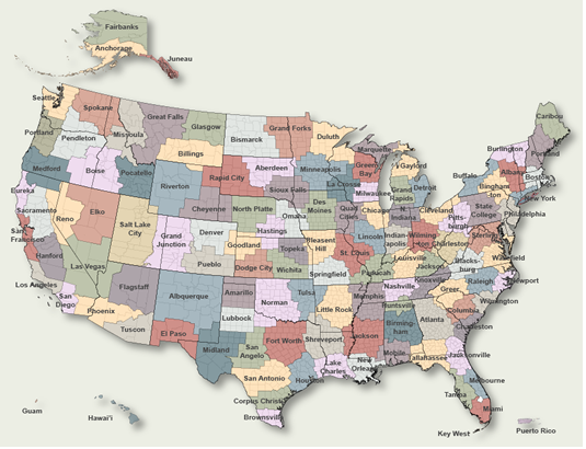
To Select Another NWS Office Click on Map or Choose from List
|
| Select Forecast Office: | Select Product: |
749 FLUS43 KOAX 160442 HWOOAX Hazardous Weather Outlook National Weather Service Omaha/Valley NE 1142 PM CDT Wed Apr 15 2026 IAZ043-055-056-069-079-080-090-091-NEZ011-012-015>018-030>034- 042>045-050>053-065>068-078-088>093-170445- Monona-Harrison-Shelby-Pottawattamie-Mills-Montgomery-Fremont-Page- Knox-Cedar-Thurston-Antelope-Pierce-Wayne-Boone-Madison-Stanton- Cuming-Burt-Platte-Colfax-Dodge-Washington-Butler-Saunders-Douglas- Sarpy-Seward-Lancaster-Cass-Otoe-Saline-Jefferson-Gage-Johnson- Nemaha-Pawnee-Richardson- 1142 PM CDT Wed Apr 15 2026 This Hazardous Weather Outlook is for southwest Iowa, west central Iowa, east central Nebraska, northeast Nebraska and southeast Nebraska. .DAY ONE...Tonight. Hazardous weather is not expected at this time. .DAYS TWO THROUGH SEVEN...Thursday through Tuesday. Warm, dry, and breezy conditions will lead to very high fire danger on Thursday, especially across northeast Nebraska. A chance of severe thunderstorms arrives Friday afternoon, especially for southeast Nebraska and southwest Iowa. All severe weather hazards are possible with this system. A Spring freeze is expected for many locations this weekend. Vegetation damage may be possible as a result. .SPOTTER INFORMATION STATEMENT... Spotter activation is not expected at this time. $$ |
Previous Hazardous Weather Outlooks may be found at
NWS Omaha, NE (OAX) Office Hazardous Weather Outlooks.
(Click 'Previous Version' there to view past versions successively.
Some may differ only in time posted.)
Products Courtesy of NOAA-NWS
NWS Information Parsing Script by Ken True at Saratoga Weather - WFO and Products Scripts by SE Lincoln Weather.
Mapping by Curly at Michiana Weather and by Tom at My Mishawaka Weather.


